 Previous Article
 Next Article
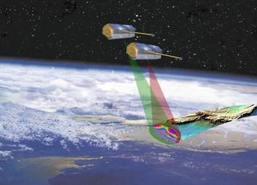
With the tandem formation TerraSAR-X/TanDEM-X, it will be possible to completely measure the Earth's land surface, which is 150 million square kilometres, within a period of only 2.5 years. EADS Astrium photo
MOSCOW (BNS): The Astrium-built TanDEM-X satellite has been tentatively scheduled for lift-off on 21 June, aboard a Dnepr launch vehicle from the Baikonur cosmodrome in Kazakhstan.
TanDEM-X (TerraSAR-X add-on for Digital Elevation Measurement) is a German program for a new generation SAR satellite operating at X-band in single pass SAR interferometry.
On 11 May, the satellite which is five metres long and weighs 1.3 tonnes, will leave Germany from Munich airport and head to the Baikonur space centre.
The satellite has proven its suitability for operation in space in a series of special tests at IABG in Ottobrunn, near Munich, a statement by EADS Astrium said.
With the almost identical TerraSAR-X satellite, operational since 2007, TanDEM-X will gather data for a digital elevation model portraying Earth's landmasses in unprecedented quality.
Collecting the data for this new model will take three years. To do this, TanDEM-X and TerraSAR-X will form a radar interferometer.
The satellites will fly in close formation, only a few hundred metres apart, enabling terrain images to be acquired simultaneously from different viewing angles.
The two satellites are scheduled to map the complete land area of Earth �150 million square kilometres � on a
12-metre grid and with a relative vertical accuracy of less than 2 metres.
As with the TerraSAR-X �sister mission�, the TanDEM-X project was implemented in a Public-Private Partnership (PPP) between Astrium GmbH and German Aerospace Centre (DLR).


The Indian Air Force, in its flight trials evaluation report submitted before the Defence Ministry l..
view articleAn insight into the Medium Multi-Role Combat Aircraft competition...
view articleSky enthusiasts can now spot the International Space Station (ISS) commanded by Indian-American astr..
view article