WASHINGTON, DC (BNS): The aerospace industry is eagerly awaiting the launch of world's highest resolution commercial earth imaging satellite on September 4 that would be able to as small an object as a home plate. The maker of the satellite, GeoEye Inc, has already tied up with popular website Google Earth and Google Maps for feeding imageries.
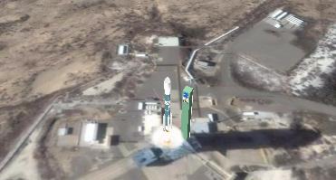
The satellite would be launched by Delta II rocket from Space Launch Complex-2 at Vandenberg Air Force base, California at 11.50.57 am (local time). The satellite, GeoEye-1, would be deployed around 58 minutes after the lift off. It is expected to establish first contact with the ground control 90 minutes after the launch and the first imagery is expected to be received by mid or late October.
The launch vehicle, Delta II 7420-10 is 12 story tall and has undergone pre-flight tests at the site.
GeoEye-1 is capable of taking color images of the earth from 681 kilometers moving at a speed of seven kilometers per second. It will make 15 earth orbits. Its imaging system can pick up even small objects on the earth's surface which are barely 16 inches in size.
The satellite would also be able to collect color imagery at 1.65 meter ground resolution. The satellite will be able to collect imagery at 0.41 meters. It would re-sample the imagery to half meter resolution for customers. The satellite would be able to take more than one million square kilometers of imagery every day.
It is so designed that the satellite would be over same location on the globe every three days that would enable it to provide regular images. Its main benefit would be big mapping projects as data would be updated at frequent intervals.
The satellite maker said the images could be utilized by a large number of industry including national defence and intelligence. Mapping would be one of the main purposes and local governments can utilize it for planning and disaster management.
Google has already shown interest in the high quality imagery. The launch vehicle would even carry a Google logo. It would be interested in taking black and white pictures of .41 meters resolution and 1.65 meters in color.
A Google official said that it would begin receiving half meter resolution imagery from the new satellite after 45 to 60 days. "The combination of GeoEye's high-resolution, map-accurate satellite imagery from GeoEye-1 and Google's search and display capabilities provides users with access to rich, interactive visual image maps of the Earth," said an official.


The Indian Air Force, in its flight trials evaluation report submitted before the Defence Ministry l..
view articleAn insight into the Medium Multi-Role Combat Aircraft competition...
view articleSky enthusiasts can now spot the International Space Station (ISS) commanded by Indian-American astr..
view article