 Previous Article
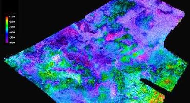
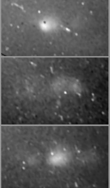
Cassini's radar mapper has obtained stereo views of close to 2 percent of Titan's surface during 19 flybys over the last five years. Image credit: NASA/JPL/USGS
CALIFORNIA (BNS): During 19 flybys of Saturn’s moon Titan, in five years, Cassini has clicked stereo views of close to two per cent of Titan’s surface thus providing a bird’s-eye view of the moon’s Earth-like landscapes.
Scientists say that the new flyover maps for the first time show the 3-D topography and height of the 1,200-meter (4,000-foot) mountain tops, the north polar lake country, the vast dunes more than 100 meters (300 feet) high that crisscross the moon, and the thick flows that may have oozed from possible ice volcanoes. The topographic maps were made from stereo pairs of radar images, they said.
Cassini radar team member Randy Kirk with the Astrogeology Science Center at the US Geological Survey in Flagstaff, Arizona, created the maps. Kirk used nearly 20 or so areas where two or more overlapping radar measurements were obtained during 19 Titan flybys. The next flyby is slated for Friday (March 27). “These stereo overlaps cover close to two percent of Titan’s surface. The process of making topographic maps from them is just beginning, but the results already reveal some of the diversity of Titan’s geologic features,” Kirk said.
He said that these flyovers give bird’s-eye sweeping views of Titan, the next best thing to being there. “We’ve mapped many kinds of features, and some of them remind me of Earth. Big seas, small lakes, rivers, dry river channels, mountains and sand dunes with hills poking out of them, lava flows,” Kirk said.
The Cassini radar team member presented the results at the Lunar and Planetary Science Conference in The Woodlands, Texas, on Tuesday.
Explaining the map, Kirk said that the high and low features are shown in unprecedented detail at about 2.4-km (1.5-mile) resolution. “The maps show some features that may be volcanic flows. These flows meander across a shallow basin in the mountains. One area suspected to be an ice volcano, Ganesa Macula, does not appear to be a volcanic dome. It may still have originated as a volcano, but it’s too soon to know for sure. It could be a volcanic feature, a crater, or something else that has just been heavily eroded,” Kirk reasoned.
The stereo coverage includes a large portion of Titan’s north polar lakes of liquid ethane and methane. Based on these topographical models, scientists should be able to determine the depth of lakes. The highest areas surrounding the lakes are some 1,200 meters (about 4,000 feet) above the shoreline. By comparing terrain around Earth to the Titan lakes, scientists estimate their depth is likely about 100 meters (300 feet) or less.
“More 3-D mapping of these lakes will help refine these depth estimates and determine the volume of liquid hydrocarbons that exist on Titan. This information is important because these liquids evaporate and create Titan’s atmosphere. Understanding this methane cycle can provide clues to Titan’s weather and climate,” Kirk added.


The Indian Air Force, in its flight trials evaluation report submitted before the Defence Ministry l..
view articleAn insight into the Medium Multi-Role Combat Aircraft competition...
view articleSky enthusiasts can now spot the International Space Station (ISS) commanded by Indian-American astr..
view article