 Previous Article
 Next Article
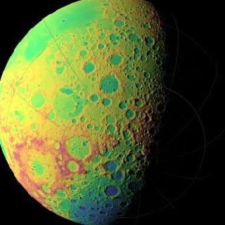
LOLA topographic map of the moon's southern hemisphere. The false colours indicate elevation: Red areas are highest and Blue lowest. Photo by NASA/GSFC/MIT/SVS
WASHINGTON (BNS): With the help of NASA's Lunar Reconnaissance Orbiter researchers will create the most precise and complete map to date of the moon's complex, heavily cratered landscape.
According to Dr. Gregory Neumann of NASA's Goddard Space Flight Center in Greenbelt, nearly 3 billion data points have been collected from the Lunar Orbiter Laser Altimeter (LOLA) on board the LRO spacecraft, with near-uniform longitudinal coverage.
“We expect to continue to make measurements at this rate through the next two years of the science phase of the mission and beyond. Near the poles, we expect to provide near-GPS-like navigational capability as coverage is denser due to the spacecraft's polar orbit," he said.
The Lunar Orbiter Laser Altimeter works by propagating a single laser pulse through a Diffractive Optical Element that splits it into five beams which create a two-dimensional spot pattern that unambiguously reveals slopes.
LOLA will also measure the spreading of the return pulse to get the surface roughness and the change in the transmitted compared to the return energy of the pulse to determine surface reflectance.
"Recent papers have clarified some aspects of lunar processes based solely on the more precise topography provided by the new LOLA maps," adds Neumann, "such as lunar crater density and resurfacing by impacts, or the formation of multi-ring basins."
"The LOLA data also allow us to define the current and historical illumination environment on the moon,” he said.
Lunar illumination history is important for discovering areas that have been shaded for long periods. Such places, typically in deep craters near the lunar poles, act like cold storage, and are capable of accumulating and preserving volatile material like water ice.
The new LOLA dataset is illuminating details of their topography for the first time. "Until LRO and the recent Japanese Kaguya mission, we had no idea of what the extremes of polar crater slopes were," Neumann said.
"Now, we find slopes of 36 degrees over several kilometers (several thousands of yards) in Shackleton crater, for example, which would make traverses quite difficult and apparently causes landslides. The LOLA measurements of shadowed polar crater slopes and their surface roughness take place at scales from lander size to kilometers. These measurements are helping the LRO science team model the thermal environment of these craters, and team members are developing temperature maps of them."


The Indian Air Force, in its flight trials evaluation report submitted before the Defence Ministry l..
view articleAn insight into the Medium Multi-Role Combat Aircraft competition...
view articleSky enthusiasts can now spot the International Space Station (ISS) commanded by Indian-American astr..
view article