 Previous Article
 Next Article
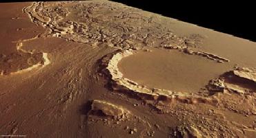
The image shows an old 35 km-diameter impact crater in the north. The crater's southwestern rim is eroded strongly, mostly by flowing water. Image credit: ESA
PARIS (BNS): European Space Agency�s Mars Express orbiter has obtained images of a long stretch of chaotic region in the Red Planet.
The images, captured by the orbiter�s High Resolution Stereo Camera (HRSC), highlight the Kasei Valles and Sacra Fossae regions of Mars, which are likely to have experienced tectonic stresses as well as �subrosion� � a process where subsurface rocks are dissolved and removed by water � causing overlying strata to collapse partially and form chaotic terrain, ESA said.
The upper portion of the image swath shows the eastern margin of Kasei Valles and the western margin of the Lunae Planum plateau and the adjoining Sacra Fossae. Kasei Valles is one of the largest outflow channels on Mars, spanning 3000 km, from the Chryse Planitia basin in the north to Echus Chasma to the south.
Sacra Fossae is a fault system that extends for more than 1000 km. It is several hundred metres deep and separates Kasei Valles to the south and west from Lunae Planum. It was named after Isola Sacra, an island at the estuary of the river Tiber in Italy.
The images show an old 35 km-diameter impact crater in the north. The crater�s south-western rim is eroded strongly. The erosion is caused mostly by flowing water. The source of the water was located in Echus Chasma, which lies roughly 850 km to the southwest.
The crater floor and the northwestern part of the imaged region are remarkably flat and have been formed by sediments and basaltic lava flows originating from the Tharsis volcanic region.
The lower part of the image clearly shows the boundary between the heavily cratered plain and the area with numerous fracture zones. Most of the fractures along the boundary are parallel to the edge of the Lunae Planum.
Several fracture zones are also visible in the western part. Up to 10-km large areas that experienced �subsidence� (gradual compaction and sinking owing to the weight of the layers) are still intact, the space agency said.


The Indian Air Force, in its flight trials evaluation report submitted before the Defence Ministry l..
view articleAn insight into the Medium Multi-Role Combat Aircraft competition...
view articleSky enthusiasts can now spot the International Space Station (ISS) commanded by Indian-American astr..
view article