 Previous Article
 Next Article
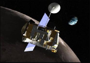
An artist's concept of LRO. Image Credit: NASA
GREENBELT (BNS): NASA�s Lunar Reconnaissance Orbiter has entered its mapping orbit of the moon after successfully completing testing and calibration phase, the US space agency has said.
�The LRO instruments, spacecraft, and ground systems continue to operate essentially flawlessly. The team completed the planned commissioning and calibration activities on time and also got a significant head start collecting data even before we moved to the mission's mapping orbit,� Craig Tooley, LRO project manager at Goddard, said on Thursday.
The moon craft is set on a year-long exploration mission in a polar orbit, about 50 kilometers above the lunar surface. During next year, it is expected to produce a complete map of the lunar surface in unprecedented detail, search for resources and safe landing sites for human explorers, and measure lunar temperatures and radiation levels, NASA said.
�The LRO mission already has begun to give us new data that will lead to a vastly improved atlas of the lunar south pole and advance our capability for human exploration and scientific benefit,� Richard Vondrak, LRO project scientist at NASA's Goddard Space Flight Centre in Greenbelt, Maryland, said.
Moon�s south pole has been of immense interest to explorers so far since it is believed to be cradling potential resources such as water ice and hydrogen.
Besides, permanently shadowed, extremely cold polar craters may hold deposits of water ice or hydrogen from comet impacts or solar wind. The deposits may have accumulated in these �cold-trap� regions over billions of years. �If enough of these resources exist to make mining practical, future long-term human missions to the moon potentially could save the considerable expense of hauling water from Earth,� the space institution said.
The LRO�s Lunar Exploration Neutron Detector (LEND) has sent images, indicating that permanently shadowed and nearby regions may harbour water and hydrogen.
�If these deposits are present, an analysis of them will help us understand the interaction of the moon with the rest of the solar system,� Vondrak said.
However, mapping of the region might not be an easy task as another instrument on board the LRO � the Lunar Orbiter Laser Altimeter (LOLA) � shows that the terrain is very rough. The roughness is probably a result of lack of atmosphere and absence of erosion from wind or water, according to David Smith, LOLA principal investigator at Goddard.
The moon craft�s other instruments are also providing data to help map the moon's terrain and resources. According to the first measurements from the Diviner instrument, large areas in permanently shadowed craters are about minus 400 degrees Fahrenheit, more than cold enough to store water ice or hydrogen for billions of years.
LRO's Lyman Alpha Mapping Project (LAMP) too is preparing to search for surface ice and frost in polar regions. The instrument provides images of permanently shadowed regions illuminated only by starlight and the glow of interplanetary hydrogen emission.
Meanwhile, LRO's Cosmic Ray Telescope for the Effects of Radiation instrument is exploring the lunar radiation environment and its potential effects on humans during record high, �worst-case� cosmic ray intensities accompanying the extreme solar minimum conditions of this solar cycle, the space agency said.


The Indian Air Force, in its flight trials evaluation report submitted before the Defence Ministry l..
view articleAn insight into the Medium Multi-Role Combat Aircraft competition...
view articleSky enthusiasts can now spot the International Space Station (ISS) commanded by Indian-American astr..
view article