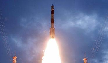
Chandrayaan launch on October 22. PTI file photo
NEW DELHI (BNS): Indian Space programme witnessed several major successes and reached great heights during the year by successfully orbiting an unmanned spacecraft Chandrayaan-1 around the Moon, launching of ten satellites in a single launch, conducting acceptance test of indigenously developed cryogenic engine successfully and the launching of a commercial satellite for an international customer.
Here is a summary of the space feats enlisted by the government�s Press Information Bureau:
YEAR ENDER 2008
Department of Space
Indian Space programme witnessed several major successes and reached great heights during the year by successfully orbiting an un-manned spacecraft Chandrayaan-1 around the Moon, launching of ten satellites in a single launch, conducting acceptance test of indigenously developed cryogenic engine successfully and the launching of a commercial satellite for an international customer.
India, in its space endeavours achieved a rare feat at 20:31 hrs on November 14, 2008 by placing the Indian tri colour when the Moon Impact Probe (MIP), one of the payloads on Chandrayaan-1 spacecraft hit the lunar surface and joined select band of countries who have placed an object on the Moon.
PSLV-C11/CHANDRAYAAN-1 MISSION
Chandrayaan-1 spacecraft, India`s first un-manned mission to the Moon was launched successfully from the Satish Dhawan Space Centre in Sriharikota at 06:22 hrs on October 22, 2008. The spacecraft was put into a transfer orbit with a perigee (nearest point to Earth) of 255 km and an apogee (farthest point to Earth) of 22,860 km, inclined at an angle of 17.9 deg to the equator. The orbit of the spacecraft was gradually raised by firing the Liquid Engine onboard Chandrayaan-1 spacecraft through carefully planned manoeuvres and was successfully inserted into the lunar orbit on November 8, 2008. Subsequently, the orbit of Chandrayaan-1 was lowered to 100 km through several manoeuvres. Chandrayaan-1 spacecraft is expected to remain in orbit for two years sending vital information on the composition of lunar soil. The precise placing of the spacecraft in lunar orbit was a unique achievement as nearly one third of the lunar missions by other countries have been lost in carrying out this crucial operation.
Chandrayaan-1 is India�s first spacecraft mission beyond Earth�s orbit. It aims to expand our knowledge about Earth�s only natural satellite � the moon by performing remote sensing of the moon using the instruments built in India and five other countries. The primary objectives of Chandrayaan-1 are to upgrade the technological base in the country for space travel, to place an unmanned spacecraft in an orbit around the moon and to conduct mineralogical and chemical mapping of the lunar surface.
Chandrayaan-1 mission aims to expand scientific knowledge about the moon and to provide challenging opportunities for planetary research to the younger generation of Indian scientists. These aims are planned to be achieved through high-resolution remote sensing of moon in the visible, near infrared, microwave and X-ray regions of the electromagnetic spectrum. With this, preparation of a 3-dimensional atlas of the lunar surface and chemical and mineralogical mapping of entire lunar surface is intended.
PSLV-C9/CARTOSAT-2A/IMS-1 MISSION
Indian Space Research Organisation created a record on April 28, 2008 by successfully launching Polar Satellite Launch Vehicle - PSLV-C9 placing ten satellites, viz., CARTOSAT-2A, Indian Mini Satellite (IMS-1) and eight nanosatellites from abroad into the orbit.
Polar Satellite Launch Vehicle with thirteen consecutively successful flights so far, has repeatedly proved itself as a reliable and versatile workhorse launch vehicle. It has demonstrated multiple satellite launch capability having launched a total of sixteen satellites for international customers besides fourteen Indian payloads including Chandryaan-1 and satellites for remote sensing, amateur radio communications and Space capsule Recovery Experiment (SRE-1). PSLV was used to launch ISRO�s exclusive meteorological satellite, KALPANA-1, into a Geosynchronous Transfer Orbit (GTO) in September 2002 and thus proved its versatility.
CARTOSAT-2A launched on April 28, 2008 is a state-of-the art 690 kg remote sensing satellite with a spatial resolution of about one metre and swath of 9.6 km. The satellite carries a panchromatic camera (PAN) capable of taking black-and-white pictures in the visible region of electromagnetic spectrum. The highly agile CARTOSAT-2A is steerable along as well as across the direction of its movement to facilitate imaging of any area more frequently. High-resolution data from CARTOSAT-2A will be invaluable in urban and rural development applications calling for large-scale mapping. The PAN camera onboard CARTOSAT-2A has started beaming high quality imagery of India and other parts of the globe.
Indian Mini Satellite (IMS-1), flown as an auxiliary payload on board PSLV-C9, is developed by ISRO for remote sensing applications. Weighing 83 kg at lift-off, IMS-1 incorporates many new technologies and has miniaturised subsystems. IMS-1 carries two remote sensing payloads � A Multi-spectral camera (Mx Payload) and a Hyper-spectral camera (HySI Payload), operating in the visible and near infrared regions of the electromagnetic spectrum. The data from this mission will be made available to interested space agencies and student community from developing countries to provide necessary impetus to capacity building in using satellite data. The cameras onboard the versatile IMS-1 has been providing high quality imagery.
INDIAONAL SATELLITE (INSAT) SYSTEM
Having established the need for a domestic communication satellite through Satellite Instructional Television Experiment (SITE) using ATS-6 satellite of USA during 1975-76, Satellite Telecommunication Experimental Project (STEP) using Franco-German Satellite Symphonie in 1978-79 and by building and utilising experimental communication satellite APPLE, the Indian National Satellite-1 (INSAT) system was operationalised in 1983. INSAT-1 satellites procured from abroad were multipurpose satellites providing telecommunication, TV broadcasting and meteorological services. INSAT-2, 3, 4 and GSAT satellites designed indigenously with higher power, more weight and capability to provide various services have been built and operationalised. India today has one of the largest domestic communications satellite systems in the Asia Pacific region with 11 operational satellites in orbit with more than 210 transponders providing vital services to the country.
The meteorological data from INSAT system is used for quick dissemination of warnings against impending disaster from approaching cyclones, specially designed receivers have been installed at vulnerable coastal areas in the country for direct transmission of warnings to the officials and public using INSAT broadcast capability.
EDUSAT, a satellite dedicated for providing educational services, was launched in September 2004. EDUSAT is providing a wide range of educational delivery modes like one-way TV broadcast, interactive TV, video conferencing, computer conferencing, web-based instructions, etc. About 34,000 classrooms that utilise EDUSAT covering 23 states have been setup across the country. These networks connect have been setup at different schools, colleges, training institutes and other departments.
Telemedicine is another important initiative to use space technology for societal benefits. It has enabled the population, even in the remotest parts, access to super specialty medical care. At present, the telemedicine network of ISRO has more than 330 installations of which about 45 are super specialty hospitals and 10 are mobile units. Till now, more than three lakh patients have been benefited annually through telemedicine system. Plans are underway to extend tele-medicine benefits to all parts of the country.
INDIAN REMOTE SENSING (IRS) SATELLITE SYSTEM
Using remote sensing satellites for earth observation was initiated with the design and development of experimental remote sensing satellites Bhaskara-1 and Bhaskara-2 during mid 70s. With seven satellites in operation - IRS-1D, OCEANSAT-1, Technology Experiment Satellite (TES), RESOURCESAT-1, CARTOSAT-1, CARTOSAT-2, CARTOSAT-2A - Indian Remote Sensing Satellite System is the largest civilian remote sensing satellite constellation in the world and provides imageries in a variety of spatial resolutions from better than one meter (CARTOSAT-2 & 2A) to 188 meter (IRS-1D). Forthcoming satellites include OCEANSAT-2, RESOURCESAT-2 and a new Radar Imaging Satellite, RISAT that can overcome the present limitation of imaging under cloudy conditions.
Using the data from IRS satellites, a variety of application programmes such as Groundwater Prospects Mapping, Crop Acreage and Production Estimation, Potential Fishing Zone Forecast, Biodiversity Characterisation at landscape level, covering four main biodiversity rich regions of the country - NE Region, Western Himalayas, Western Ghats and Andaman and Nicobar Islands - have been operationalised.
Village Resource Centres (VRCs): In order to reach space-based services directly to the rural population, establishment of Village Resource Centres (VRC) was launched in 2004. VRCs provide a variety of space based products and services including tele-education, telemedicine and information on natural resources. So far, nearly 400 VRCs have been set up in association with NGOs/Trusts, Institutes and Government Agencies.
SATELLITE LAUNCH VEHICLES
From launching of modest sounding rockets of the 1960s, India has now acquired capability to launch remote sensing satellites using Polar Satellite Launch Vehicle (PSLV) and geosynchronous communication satellites using GSLV. PSLV is capable of launching more than 1.5 tonne satellite into polar sun-synchronous orbit. Geosynchronous Satellite Launch Vehicle (GSLV) can launch a 2 to 2.5 tonne satellite into Geo-stationary Transfer Orbit (GTO). GSLV has four successful flights out of five missions with the last one being GSLV-F04/INSAT-4CR mission on September 2, 2007. Development of an indigenous cryogenic stage to replace the presently used Russian cryogenic stage has been successfully realised. Flight acceptance test of the cryogenic engine was conducted successfully on December 18, 2008.
GSLV-Mk III, which is under development, will be capable of launching satellites weighing four tonne into GTO. Several developments including recoverable and reusable space transportation systems are in progress with the objective of reducing the cost of access to space.
COMMERCIAL SUCCESSES
Antrix, the commercial arm of the Department of Space, is a single window agency for marketing Indian space capabilities. It is playing a key role in the worldwide availability of IRS data through Geoeye, USA. Antrix also provides IRS data processing equipment. Antrix offers launch services using India�s PSLV. So far sixteen satellites have already been successfully launched by PSLV for various international customers. Through Antrix, Telemetry, Tracking and Command support from the Indian ground stations are offered to various satellite operators. Similarly, lease of transponders from INSAT system has been made possible. In this regard, 11 transponders have already been leased to INTELSAT. Customers for the spacecraft components offered by Antrix include world�s leading spacecraft manufacturers. During the year, W2M satellite built by ISRO/Antrix under an agreement entered into with EADS Astrium, Paris was launched successfully on December 20, 2008. Besides, Antrix has won contracts from Europe and Asia for launch services in the highly competitive international launch services market. After the successful development of a low cost, compact, modular and rugged Automatic Weather Station (AWS) in co-ordination with industry, the technology has been licensed to industry for regular production. Thus, in addition to successfully developing spacecraft and launch vehicle technologies indigenously, India has also been successful in the application of satellite technology to benefit its national economy. At the same time, India has also been sharing space-based information with the international community and providing commercial space services globally.
FUTURE PROSPECTS
Chandrayaan-1 has successfully demonstrated the country�s capability and expertise in accomplishing highly complex space missions. The success of Chandrayaan � 1 has paved way for undertaking missions to moon and beyond. While the accomplishments so far have given a unique status to the country in the comity of space faring nations, the space programme in the country is poised for several major breakthroughs in the development of advanced technology needed for realization of the future launch vehicle and spacecraft missions in the coming years. Efforts are under way to establish necessary infrastructure for casting large boosters, liquid propellant engines, heavy cryo boosters and for development of advanced missions in the area of remote sensing, communications, navigational satellites and space science systems. Necessary ground infrastructure for providing mission support during launch phase and in orbit support for the planned missions is under realization. With the successful realization and on-orbit performance of the space systems, we can confidently look forward to make substantial inroads into the competitive international launch services and satellite markets.
 Next Article



The Indian Air Force, in its flight trials evaluation report submitted before the Defence Ministry l..
view articleAn insight into the Medium Multi-Role Combat Aircraft competition...
view articleSky enthusiasts can now spot the International Space Station (ISS) commanded by Indian-American astr..
view article