 Previous Article
 Next Article
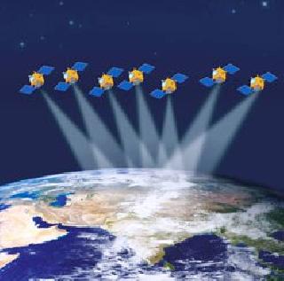
Indian Regional Navigation Satellite System (IRNSS) is an independent regional navigation satellite system. It is designed to provide position accuracy better than 10m over India and the region extending about 1500 kms around India. Photo: ISRO.
BANGALORE (PTI): India plans to launch its first navigational satellite in June, a top official of the Department of Space (DoS) said Saturday.
The first satellite of Indian Regional Navigation Satellite System (IRNSS) constellation, IRNSS-1 will be launched by PSLV-C22, said DoS Secretary and Chairman of Indian Space Research Organisation (ISRO) K Radhakrishnan.
According to ISRO officials, IRNSS is an independent regional navigation satellite system, designed to provide position accuracy of better than 10 metres over India and the region extending about 1500 km around the country.
"It is designed to provide an accurate real time Position, Navigation and Time (PNT) services to users on a variety of platforms with 24x7 service availability under all weather conditions", an ISRO official said.
IRNSS provides two basic services -- standard positioning service for common civilian users and restricted service for special authorised users, the official said.
"We are planning for June launch", Radhakrishnan told reporters after addressing a symposium on 'Indian Remote Sensing Satellite (IRS) Series: A Saga of 25 years'.
IRNSS-1 would be tested in orbit for three-four months once it's launched, he said. ISRO has planned to have a constellation of seven satellites under IRNSS.
Speaking at the event, marking the 25th anniversary of the launch of India's first operational Remote Sensing Satellite IRS-1A, Radhakrishnan said India has planned 12 missions (both launch vehicles and satellites put together) in the next one year.
These include the Rs 450 crore Mars orbiter mission in October-November aimed at demonstrating India's technological capability to reach Martian orbit and paving the way for future scientific exploratory missions, and GSLV-Mk III experimental venture.
The GSLV-Mk III is conceived and designed to make ISRO fully self-reliant in launching heavier communication satellites of INSAT-4 class, which weigh 4500 kg to 5000 kg.
Radhakrishnan said India's remote sensing satellites are able to take images with a resolution of less than a metre (0.8 metres to be precise, according to an ISRO official).
This means in those images, the official said, even ground features which are a little less than a metre wide can be recognised.
Radhakrishnan said ISRO proposed to launch remote sensing satellites with 0.6 metre resolution in two years and 0.25 metre in five years.
Former ISRO Chairmen U R Rao and K Kasturirangan spoke about the origin, growth and emergence of India as a world leader in the realm of satellite-based remote sensing in the past 25 years, at the two-day symposium, organised by Indian Society of Remote Sensing (ISRS) in partnership with other professional societies.
India today has 11 functioning remote sensing satellites, some of which are serving the country as well as the global community, according to ISRS.
India now has the largest constellation of remote sensing satellites in the civilian domain, dedicated to three main themes -- land & water, cartography, oceanography and environment, including meteorology and weather monitoring, it was noted.


The Indian Air Force, in its flight trials evaluation report submitted before the Defence Ministry l..
view articleAn insight into the Medium Multi-Role Combat Aircraft competition...
view articleSky enthusiasts can now spot the International Space Station (ISS) commanded by Indian-American astr..
view article