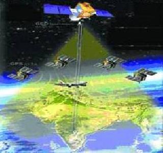
A file photo.
NEW DELHI (PTI): A satellite-based navigation system to aid air traffic from Southeast Asia to Africa, including over the high seas in the vast region, would be launched Tuesday, placing India into a select group of nations which possess such a sophisticated technology.
GAGAN or the GPS Aided Geo Augmented Navigation to be launched by Civil Aviation Minister Praful Patel would not only help the civil aviation sector but also help in marine navigation, search and rescue operations, rail and road transport, survey and mapping as well as precision farming.
So far, only the US, Europe and Japan have developed similar capabilities. GAGAN would fill the gap between the European EGNOS and the Japanese MSAS systems to provide seamless air navigation service across regional boundaries, an official spokesperson said.
The system, developed jointly by the Indian Space Research Organisation and Airports Authority of India, would operationalise a satellite-based Indian Flight Information Region in conjunction with all nations from Southeast Asia, Gulf and West Asia and the eastern coast of Africa.
It would be based on a satellite constellation consisting of 24 satellites positioned in six earth-centered orbital planes, she said.
When commissioned, GAGAN is expected to provide civil aeronautical navigation signals consistent with International Civil Aviation Organization (ICAO) standards based on the Global Navigation Satellite System (GNSS) Panel, as part of the Future Air Navigation System for the aviation sector.
GAGAN would benefit the sector in a major way, including enabling aircraft to fly on direct straight-line routes.
Currently, the planes fly over the land-based radars which are not installed in a straight line. GAGAN would help them navigate on a straight line as it is dependent on satellite route guidance and thus enhance fuel savings.
The system would help in 'precision approach' while landing at all airports in this vast region.
It would not only result in savings on ground-based radar systems, but also improve air traffic capacity through reduced aircraft separation, that is more planes can be accommodated in a limited airspace.
GAGAN would also enhance air-to-air surveillance and provide minimum safe altitude warning, besides facilities for controlled flight into terrain, the absence of which becomes a major cause for aircrashes while landing.
The project involves establishment of 15 Indian Reference Stations, three Indian Navigation Land Uplink Stations, three Indian Mission Control Centers and installation of all associated softwares and communication links.
 Previous Article
 Next Article






The Indian Air Force, in its flight trials evaluation report submitted before the Defence Ministry l..
view articleAn insight into the Medium Multi-Role Combat Aircraft competition...
view articleSky enthusiasts can now spot the International Space Station (ISS) commanded by Indian-American astr..
view article