 Previous Article
 Next Article
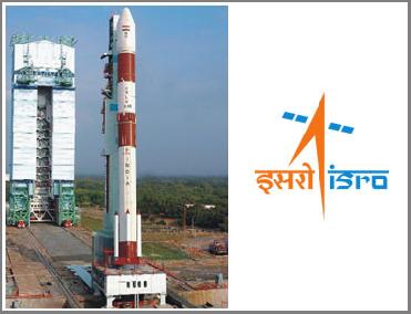
The PSLV-C15 rocket on its launch pad in Sriharikota spaceport. An ISRO photo
BANGALORE (PTI): Preparations are in full swing in Sriharikota spaceport for next week�s launch of India�s advanced remote sensing satellite Cartosat-2B by work-horse rocket Polar Satellite Launch Vehicle (PSLV-C15).
�PSLV-C15 is slated to be launched at 9.22 AM (IST) on July 12,� Indian Space Research Organisation (ISRO) spokesperson S Satish said.
The launch, from the spaceport in the east coast, was earlier fixed for May 9, 2010 but it had been rescheduled after a marginal drop in pressure in the second stage of the vehicle was noticed during mandatory checks on the rocket.
The stage is now set for the launch of PSLV-C15, carrying on board the 694-kg Cartosat-2B, a 116-kg Algerian satellite ALSAT-2A, two nano satellites NLS 6.1 and NLS 6.2 from University of Toronto, Canada, weighing 6.5 kg and STUDSAT, a satellite built by students from academic institutions in Karnataka and Andhra Pradesh, weighing less than one kg.
Cartosat-2B, the 17th remote sensing satellite of India, is mainly intended to augment remote sensing data services to the users of multiple spot scene imagery with 0.8 metre spatial resolution and 9.6 km swath in the panchromatic band.
The multiple spot scene imagery sent by Cartosat-2B's panchromatic camera would be useful for village level/cadastral level resource assessment and mapping, detailed urban and infrastructure planning and development and transportation system planning.
It will also prove useful in preparation of large-scale cartographic maps, preparation of micro watershed development plans and monitoring of developmental works at village/ cadastral level, according to ISRO.
Cartosat-2B's imagery, the space agency said, can also be used to prepare detailed forest type maps, tree volume estimation, village/cadastral level crop inventory, town/village settlement mapping and planning for comprehensive development.
The imagery could also be used for canal alignment, rural connectivity assessment, planning new rural roads and monitoring their construction, coastal landform/land use and coral/mangrove mapping and monitoring of mining activities, ISRO said.


The Indian Air Force, in its flight trials evaluation report submitted before the Defence Ministry l..
view articleAn insight into the Medium Multi-Role Combat Aircraft competition...
view articleSky enthusiasts can now spot the International Space Station (ISS) commanded by Indian-American astr..
view article