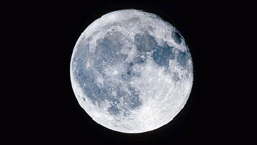
NASA image
WASHINGTON (BNS): A detailed map of the Moon published in the February 13 issue of the journal Science reveals the never-before-seen craters at the lunar poles. The map also reveals secrets about the Moon's interior -- and gives clues about Mars's interior as well.
C K Shum, professor of Earth Sciences at Ohio State University, who is part of the international research team, said that the surface can tell us a lot about what's happening inside the Moon, but until now mapping has been very limited. “For instance, with this new high-resolution map, we can confirm that there is very little water on the Moon today, even deep in the interior. And we can use that information to think about water on other planets, including Mars,” Shum said.
Researchers using the laser altimeter (LALT) instrument aboard the Japanese Selenological and Engineering Explorer (SELENE) satellite mapped the Moon at an unprecedented 15-km (9-mile) resolution. Hiroshi Araki of the National Astronomical Observatory of Japan is the principal investigator of the LALT instrument and lead author of the study, while Shum is a member of the LALT science team.
An Ohio State University release said that the map was the first to cover the Moon from pole to pole, with detailed measures of surface topography, on the dark side of the moon as well as the near side. The highest point -- on the rim of the Dririchlet-Jackson basin near the equator -- rises 11 km (more than 6.5 miles) high, while the lowest point -- the bottom of Antoniadi crater near the south pole -- rests 9 km (more than 5.5 miles) deep.
In part, the new map will serve as a guide for future lunar rovers, which will scour the surface for geological resources, astronomers said.
Araki and his colleagues measured the roughness of the lunar surface, and used that information to calculate the stiffness of the crust. “If water flowed beneath the lunar surface, the crust would be somewhat flexible, but it wasn't. The surface was too rigid to allow for any liquid water, even deep within the Moon,” they noted.
Talking about Mars, astronomers said that on a scale of surface roughness, it falls somewhere between the Earth and the Moon, which indicates that it may have once been liquid water, but that the surface is now very dry.
“But Mars' roughness coupled with the complete absence of plate tectonics suggests that if there is water in the red planet's interior, it is not located near the surface, where it could lubricate the crust,” Shum explained.
The LALT map is the most detailed lunar map ever created. The last three Apollo missions mapped part of the surface in the early 1970s, and the 1994 Clementine mission in offered a resolution between 20-60 km in certain locations, but not the entire surface, the astronomers said.
The SELENE mission offers 15-km resolution consistently over the entire surface, because it features two smaller sub-satellites which closely track the main satellite.
“This design significantly improved our ability to model gravity fields on the moon, and let us compute the main satellite's orbit more accurately than was possible before, especially over the far side of the Moon. That led to more accurate measurement of the lunar topography using LALT,” Shum said.
Astronomers said that the map revealed several small craters at the north and south poles that hadn't been seen before. For example, a 15-km-wide crater can be seen inside the much larger de Gerlache crater at the South Pole, they said.
It is hoped that the new details will help guide future lunar rovers during future geological research missions.
 Previous Article
 Next Article








The Indian Air Force, in its flight trials evaluation report submitted before the Defence Ministry l..
view articleAn insight into the Medium Multi-Role Combat Aircraft competition...
view articleSky enthusiasts can now spot the International Space Station (ISS) commanded by Indian-American astr..
view article