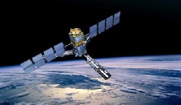
The Soil Moisture and Ocean Salinity (SMOS) mission makes global observations of soil moisture over Earth�s landmasses and salinity over the oceans. An Esa photo
NEW DELHI (BNS): ESA's SMOS satellite completed its six-month commissioning this week and formally began operational life.
The mission is now set to provide much-needed global images of soil moisture and ocean salinity to help understand the water cycle, Esa said in a statement.
The Soil Moisture and Ocean Salinity (SMOS) satellite was launched on 2 November last year, and has since undergone an intense programme of calibration and commissioning in preparation for its life in service.
During a three-day review this week in �vila, Spain, all the elements of the mission were found to be in excellent shape.
SMOS employs a novel interferometric radiometer that operates in the L-band microwave range to capture �brightness temperature� images. These images are used to produce global maps of soil moisture every three days and maps of ocean salinity averaged over 30 days.
By consistently mapping these two variables, SMOS is expected to advance knowledge of the exchange processes between Earth�s surface and atmosphere and also help to improve weather and climate models.
In addition, the data will also be used for practical applications in areas such as agriculture and water resource management.
ESA has placed three of its Earth Explorer satellites in orbit within a little over 12 months. The GOCE gravity mission was launched in March 2009, followed by SMOS in November and the CryoSat ice mission last month.
Results from these three missions will be presented to the scientific community at the Living Planet Symposium at the end of June in Bergen, Norway.
 Previous Article
 Next Article









The Indian Air Force, in its flight trials evaluation report submitted before the Defence Ministry l..
view articleAn insight into the Medium Multi-Role Combat Aircraft competition...
view articleSky enthusiasts can now spot the International Space Station (ISS) commanded by Indian-American astr..
view article