 Previous Article
 Next Article
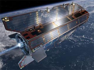
GOCE (Global Ocean Circulation Explorer). Photo: ESA.
WASHINGTON (PTI): After mapping variations in Earth's gravity with unprecedented detail for four years, the European Space Agency's GOCE satellite has run out of fuel and the end of mission has been declared on Monday.
Since March 2009, the Gravity field and steady-state Ocean Circulation Explorer (GOCE) has been orbiting Earth at the lowest altitude of any research satellite.
"On 21 October, the mission came to a natural end when it ran out of fuel. The satellite is expected to reenter Earth's atmosphere in about two weeks," the ESA said in a statement.
Data acquisition and satellite operations will continue for about two more weeks until its systems stop working because of the harsh environmental conditions at such a low altitude.
At this point, the satellite will be switched off, marking the end of activities for the GOCE flight control team.
While most of the satellite will disintegrate in the atmosphere, Some smaller parts are expected to reach Earth's surface. When and where these parts might land cannot yet be predicted, but the affected area will be narrowed down closer to the time of reentry, the agency said.
Although the planned mission was completed in April 2011, the fuel consumption was much lower than anticipated because of the low solar activity, enabling ESA to extend GOCE's life.
In August 2012, the control team began to lower the satellite's orbit - from about 255 km to 224 km.
Dubbed 'GOCE's second mission', the lower orbit increased the accuracy and resolution of GOCE's measurements, improving the view of smaller ocean features such as eddy currents.
Its 'gradiometer' - the sensitive instrument measuring gravity in 3D - was the first in space and has mapped variations in Earth's gravity with unrivalled precision.
The result is a unique model of the 'geoid', which is essentially the shape of an ideal global ocean at rest and therefore critical for accurate measurements of ocean circulation and sea-level change.
Scientists have used GOCE's data to create the first global high-resolution map of the boundary between Earth's crust and mantle - called the Moho.
The satellite also became the first seismometer in orbit when it detected sound waves from the massive earthquake that hit Japan on March 11, 2011.
"This innovative mission has been a challenge for the entire team involved: from building the first gradiometer for space to maintaining such a low orbit in constant free-fall, to lowering the orbit even further," said Volker Liebig, ESA's Director of Earth Observation Programmes.
"The outcome is fantastic. We have obtained the most accurate gravity data ever available to scientists. This alone proves that GOCE was worth the effort - and new scientific results are emerging constantly," Liebig said.


The Indian Air Force, in its flight trials evaluation report submitted before the Defence Ministry l..
view articleAn insight into the Medium Multi-Role Combat Aircraft competition...
view articleSky enthusiasts can now spot the International Space Station (ISS) commanded by Indian-American astr..
view article