 Next Article
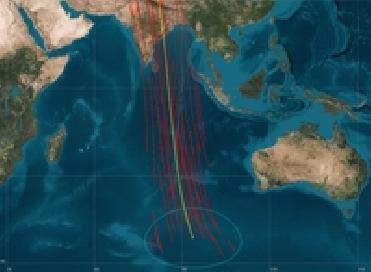
The PARIS Ocean Altimeter would provide multiple observations (red lines) which could capture a tsunami wave travelling in the ocean; current conventional altimeters can make only one observation (yellow line). ESA photo
PARIS (BNS): With an objective to track the changing contours of the Earth's ocean, land and ice surfaces, the European Space Agency (ESA) is planning a mission which would harness satellite navigation signals that constantly fall on the planet and bounce back to space.
The proposed mission, named Passive Reflectometry and Interferometry System (PARIS), will track multiple signal bounces at once, and will help build up a rapid picture of fast-moving mid-sized phenomena such as storms, current eddies and high waves occurring in our planet, according to the ESA.
A rain of navigation signals falls constantly on Earth from a number of satellites, providing positioning and guidance services. These microwave beams then bounce back to space . The PARIS mission aims to explore their potential for terrestrial remote sensing applications, the space agency said.
�At the heart of the mission is a double-sided antenna made up of many small elements that can track multiple signals from above and below in parallel,� PARIS project researcher Manuel Mart�n-Neira said. �The phase difference of original and bounced-back signals originating from the same satellite are then compared to reveal the difference in their travel time and obtain ranging information,� he added.
�The principle has been proven with airborne demonstrators, but the high-gain satellite-tracking antenna we require for maximum ranging accuracy can only be tested in space,� the ESA scientist said.
The proposed PARIS In-Orbit Demonstrator mission would include a 1.1-m antenna to prove the concept, with any future operational mission being equipped with a larger 2.4-m antenna.
PARIS is a passive variation on an existing instrument called a radar altimeter, currently flying on ESA's Envisat and other Earth-observing satellites.
The altimeters fire 1800 microwave pulses downward per second then measures their echo return time to calculate sea surface height. As ocean currents and eddies form height undulations on the sea surface of the order of tens of centimetres, altimetry results gradually yield to a rich and scientifically valuable map of ocean circulation. Current altimeters sample only one point at a time, while PARIS would measure multiple points with a faster revisit time, yielding new data on rapidly-changing features, the ESA said.
�PARIS would complement rather than replace existing altimetry,� said Mart�n-Neira.


The Indian Air Force, in its flight trials evaluation report submitted before the Defence Ministry l..
view articleAn insight into the Medium Multi-Role Combat Aircraft competition...
view articleSky enthusiasts can now spot the International Space Station (ISS) commanded by Indian-American astr..
view article