 Previous Article
 Next Article
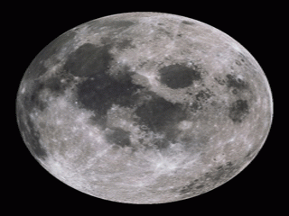
A NASA photo.
BEIJING (PTI): Chinese scientists have claimed to develop methodologies for precise mapping of the Moon, including creating an accurate 3D models of lunar surface.
The Hong Kong Polytechnic University (PolyU) said that its surveying experts had successfully developed methodologies for precise mapping of the Moon, after intensive analysis of the data captured by the Chinese lunar orbiter ChangE-1 and other lunar exploration missions.
According to the PolyU, their efforts culminated in the development of a unique and innovative approach to the creation of accurate 3D models of the lunar surface, Chinese state-run Xinhua news agency reported.
The team has produced the most updated parameters of the lunar figure (the shape of the moon), which is essential for lunar mapping using 17.5 million laser altimetry measurements from the ChangE-1and the Japanese SELENE missions.
In addition, they also used the new topographic and gravity models to calculate improved crustal thickness and mass distribution of the Moon and established that the average thickness of the Moon's crust is about 40 kilometres on the near side and 50 kilometres on the far side.
It was introduced that the resulting lunar mapping was the hard work of a dedicated research team led by Professor Chen Yong-qi, Emeritus Professor of the Department of Land Surveying and Geo-Informatics, who is also serving on the Expert Committee of China's Lunar Exploration Programme (ECCLEP).
The other members of the team included Professor Chen Wu, Professor Ding Xiao-li, Professor Baki Iz, Bruce King, and Wu Bo, with all of them making concerted efforts for the success of the programme.
According to Chen Yong-qi, the lunar mapping project started in 2006.
The primary objective was to develop the methodologies and techniques for mapping the Moon surface, which is much more challenging than mapping the Earth's surface because of very few surveyed control points which are essential for accurate map making, Prof Chen Yong-qi said.
Statistics showed that there were only fourteen lunar laser ranging retro reflectors (LRRR) and Apollo lunar surface experiment package (ALSEP) transmitter sites with accurately known coordinates available only on the near side of the Moon, installed by the US Apollo and former Soviet Union Luna missions in the 1960s.
Moreover, according to the team, the gravitational field of the Moon is not as well-known as that of Earth, which means the accuracy of the computed lunar satellite's position at any given time is lower than for Earth satellites, thus degrading the mapping accuracy and reliability.
In addition, the team expressed that highly reflective lunar surface created significant problems for the automatic processing of images to develop 3D models using the technique of photogramemtry, which is a widely used and highly reliable technique for the creation of maps and 3D models on Earth.
Furthermore, the team also revealed they had a plan to compare such data with other data sources in order to evaluate the performance of the ChangE mapping sensors.
Since Chen Yong-qi is serving on the ECCLEP, the team has direct access to more recent data captured by the ChangE satellite.


The Indian Air Force, in its flight trials evaluation report submitted before the Defence Ministry l..
view articleAn insight into the Medium Multi-Role Combat Aircraft competition...
view articleSky enthusiasts can now spot the International Space Station (ISS) commanded by Indian-American astr..
view article